Tropical disturbance Harvey may be bringing some rough weather through the Gulf Coast area in the coming days.
Videos by Rare
RELATED: Extreme Weather Leaves Hundreds Stranded at Airports Overnight
Downgraded from a tropical storm on Sunday, Harvey is still expected to wash over the coast in a wave of rainy weather, a portion of which is on track to hit parts of Florida Tuesday, according to the Sun-Sentinel.
As of this morning, the chances of Harvey ramping back up into a full-fledged tropical storm are listed as 70 percent in the next two days and 90 percent in the next five.
#Harvey is expected to become a tropical cyclone again on Wed or Thu. Interests in NE Mexico & Texas should monitor https://t.co/tW4KeGdBFb pic.twitter.com/TNEpgEax66
— National Hurricane Center (@NHC_Atlantic) August 22, 2017
As the wave hits land, the Gulf Coast of Texas is in one of the areas of heaviest projected rainfall areas.
Screen shot of Reddit.com/Prof_Graph’s post
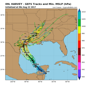
According to the website tropicaltidbits.com, which monitors tropical storms, disturbances and other events, the radius of Harvey is around 120 nautical miles, and the radius of maximum wind is 90 nautical miles.
Of course, even if you’re out of the direct path of a storm, you can still be dangerously affected.
Areas outside the direct path of Harvey may experience heavy rainfall and flooding, as well.
RELATED: Even if You’re Outside the Path of a Storm, There’s a Lot to be Concerned by This Hurricane Season
Like the last bout of heavy rain, parts of Houston regularly flood during heavy rainfall, so be prepared.


